Mapping Work Support at STS!
16 April 2020
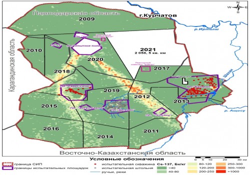
The National Nuclear Center of RK conducts mapping support operations for radioecological survey of the former Semipalatinsk Test Site territory.
This is one of the most important stages in planning of fieldwork that includes determining the survey sites, building a regular sampling network, generating schematic maps of the radionuclides distribution of both artificial and natural origin in accordance with the results of field and laboratory studies of the selected samples, etc.
Currently, the first batch of passport data (field sampling results) for the eastern part of the STS territory has already been received. The results of the selected samples are entered into the database, and further the actual mapping material easily accessible for understanding (maps, charts, graphs and tables, etc.) will be obtained through laboratory measurements-based GIS-analysis.
Latest news by category:
-
IAEA Sidelines Consultation Meeting
31 July 2026
-
Second Session of “Young Physicist – 2026” Summer School Held at NNC RK
30 July 2026
-
Welcome Day in the exhibition hall of the Semipalatinsk Test Site’s History
23 July 2026
-
International Conference “Final RW Disposal – Key Element of Safety and Sustainable Development of Atomic Energy” Opens at NNC RK
22 July 2026